- Activities
MAPS is a collective effort proposing new ways and approaches of storytelling to address the world's changing environment and societies.
MORE- Works
- Cultural
- Education
- Collective projects
- Members
MAPS brings together various dedicated professionals who want to start a new adventure and learn from each other in the process.
MORE- Photographers
- Creatives
- Contributors
- Foundation
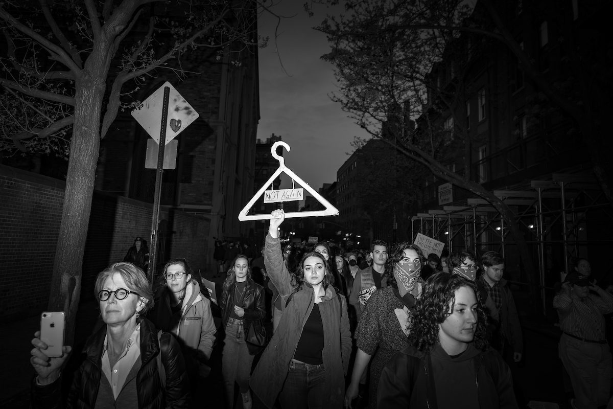
Fighting for abortion rights
John Trotter
On June 24, 2022, the US Supreme Court overturned Roe vs. Wade, the landmark 1973 ruling that affirmed the constitutional right to abortion. Thousands of people, mostly women, marched in New York City and all around the United States to protest against this decision. But women didn't wait for the terrible news to take the…
More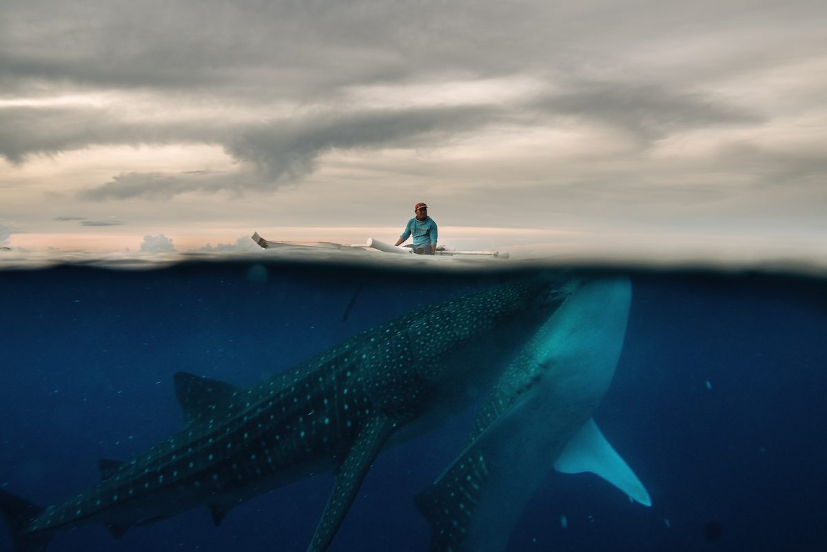
Please Don't Feed the Whale Sharks?
Hannah Reyes Morales
The chance to swim with the world’s biggest fish drew tourists to a Philippines town, but conservation groups denounce the hand-feeding that keeps the gentle creatures around. In an assignment for The New York Times, Hannah Reyes Morales explored the difficult questions being asked about a controversial relationship between an endangered species and a community…
More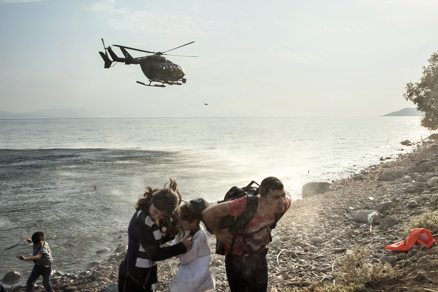
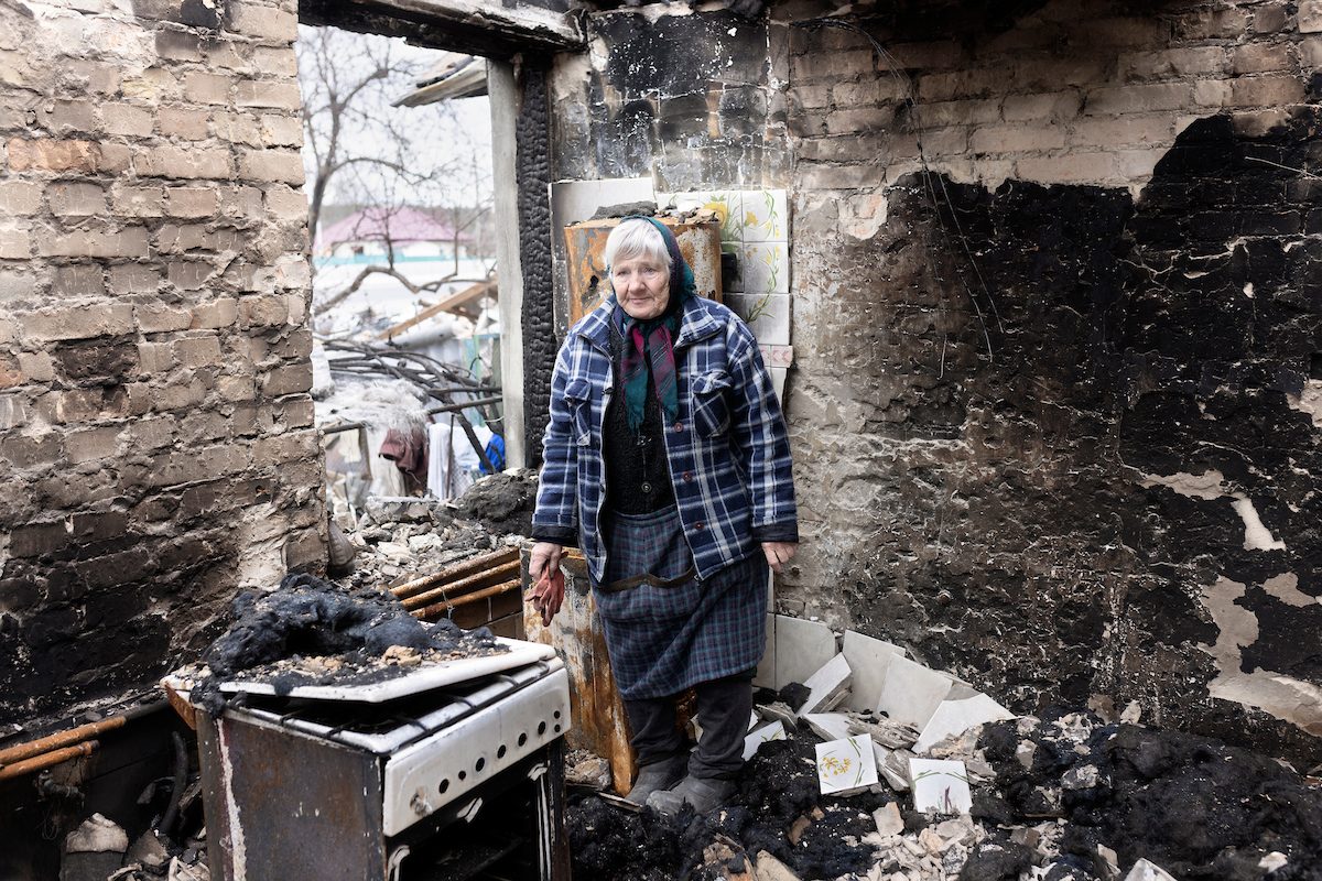
Ukraine, life among the ruins
Alessandro Penso
In Bucha, the Russian army left a city in ruins and traces of appalling crimes. More than 420 bodies have already been found. In the Kiev region, prosecutors have already documented 1,084 crimes against civilians, while in the whole of Ukraine, 3,818 civilians have been killed and more than 4,000 injured. Yet, these figure do…
More
Ukraine, the silence left by the war
Massimo Berruti
The Kiyv region is now a ghost area, where the echo of fear and violence resonate in the silence left behind by the war. Massimo Berruti was in Borodyanka, Irpin or Bucha, near the capital, to document the horror unveiled by the withdrawal of the Russian army. Two months after the start of the war…
More
Isola
Simona Ghizzoni
“We have lived our lives by the assumption that what was good for us would be good for the world. We have been wrong. We must change our lives so that it will be possible to live by the contrary assumption, what is good for the world will be good for us. And that requires that we make the effort to know the world and learn what is good for it.”
More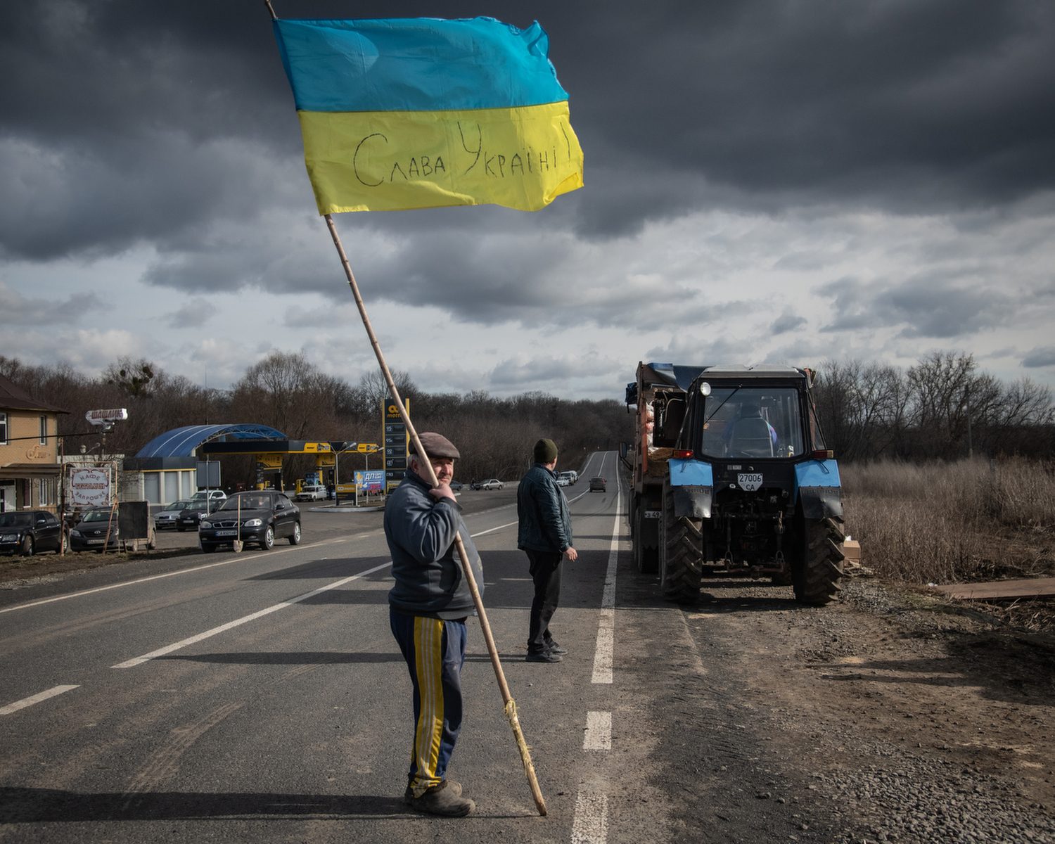
Ukraine, Civilian Resistance
Justyna Mielnikiewicz
Russia's full-scale invasion of Ukraine in February 2022 was a shock to Ukrainians, but not a surprise. They had been at war since 2014, ever since Russian soldiers in green uniforms without insignia annexed Crimea and continued, hiding behind the backs of local separatists in Slovyansk, Krematorsk and then Donetsk. Russia took a territorial bite…
More
A Ukraine Runs Through It
Justyna Mielnikiewicz
Project explores modern Ukraine in turmoil with the Dnieper river a metaphor of present split in the country. It documents how the mixed ethnic and historical legacies of Ukraine brought people to their present realities. Making Dnieper river a symbolic line of reference allows me to talk about most important issues in wider political, historical…
More
Latest Work

Fighting for abortion rights
John Trotter
On June 24, 2022, the US Supreme Court overturned Roe vs. Wade, the landmark 1973 ruling that affirmed the constitutional right to abortion. Thousands of people, mostly women, marched in…
More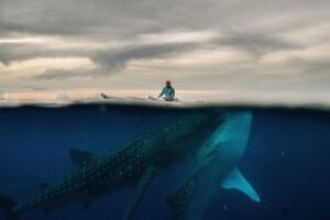
Please Don't Feed the Whale Sharks?
Hannah Reyes Morales
The chance to swim with the world’s biggest fish drew tourists to a Philippines town, but conservation groups denounce the hand-feeding that keeps the gentle creatures around. In an assignment…
More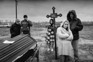
Ukraine, the silence left by the war
Massimo Berruti
The Kiyv region is now a ghost area, where the echo of fear and violence resonate in the silence left behind by the war. Massimo Berruti was in Borodyanka, Irpin…
More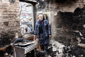
Ukraine, life among the ruins
Alessandro Penso
In Bucha, the Russian army left a city in ruins and traces of appalling crimes. More than 420 bodies have already been found. In the Kiev region, prosecutors have already…
More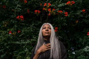
Redefining Beauty
Hannah Reyes Morales
Throughout history, beauty has played an integral role across human societies. Today, what Darwin once phrased ‘the taste for the beautiful’ remains ubiquitous in our lives. I came into this…
More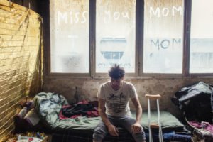
Frontiera
Alessandro Penso
After the closure of the main Balkan migration route in 2015 and an EU deal with Turkey a year later, the number of refugees, asylum seekers and migrants knocking on…
More
Adolescent Mothers at Risk
Ashfika Rahman
In Kamrangirchar (Bangladesh), many girls are married at a young age and face early parenthood. However, the needs of these girls and young women are often overlooked in the health…
More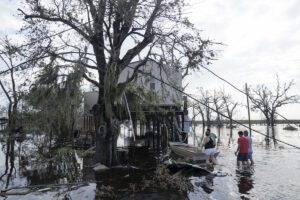
Hurricane Ida Aftermath
Kitra Cahana
Grand Isle, Louisiana, has always existed at the mercy of weather from the Gulf. For centuries it endured a harrowing cycle of destruction and reconstruction, as storm after storm razed…
More
Isola
Simona Ghizzoni
“We have lived our lives by the assumption that what was good for us would be good for the world. We have been wrong. We must change our lives so that it will be possible to live by the contrary assumption, what is good for the world will be good for us. And that requires that we make the effort to know the world and learn what is good for it.”
More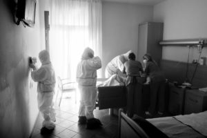
Italy, The First Western Outbreak
Massimo Berruti
Italy was the first country to face an outbreak of Coronavirus in the west. On 10 March 2020, the country enters lockdown to the disbelief of its inhabitants as well…
More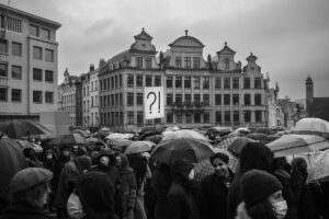
Brussels with COVID-19
Views of the Belgian capital throughout the successive waves of the pandemic. From March 2020 to December 2021.
More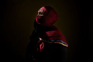
COVID-19 in Wealthy Switzerland
Dominic Nahr
Switzerland is one of the wealthiest countries in the world and has been listed in 2020 as the most expensive country to live in, in 2020, by CEOWORLD. Because of…
More
Colonial Legacy in Belgium
In the streets of Brussels, the colonial past is hidden in plain sight. The many street names and monuments honouring personalities, places and events linked to colonial history are so…
More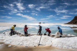
The Rush for White Gold
Cédric Gerbehaye
What gold meant to earlier eras, and petrolum to the previous century, lithium may eclipse in the coming years. As demand soars for powerful batteries, Bolivia dreams of striking it…
More
Adrift in Blue
Nicolas Janowski
"Adrift in blue" is the story of a legendary place, from the moment that the imaginary of the End of that Inhospitable World is installed until its transmutation into a…
More
Liquid Serpent
Nicolas Janowski
The Amazon is neither man nor animal. She is nature’s hybrid. Mirrors of man’s contradiction, of a world to which she belongs and yet remains distant. The Amazon bears forth…
More
Condor
João Pina
In 1975, at the height of the Cold War, six Latin American countries (Argentina, Bolivia, Brazil, Chile, Uruguay and Paraguay) then ruled by right wing military dictatorships, created Operation Condor.…
More
Cuba's New Special Period
João Pina
With the death of Fidel Castro and his brother Raul’s retirement, Cuba is now living a new “special period” somehow similar to what happened in the 1990’s after the collapse…
More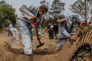
Coronavirus in Mexico
Daniel Berehulak
"In the Epicenter of Mexico’s Epicenter, Feeling Like a ‘Trapped Animal’"
More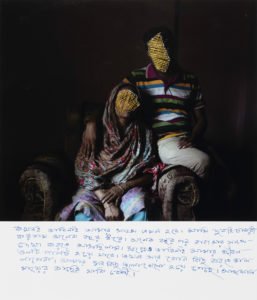
Files of the Disappeared
Ashfika Rahman
2018-ongoing Photography has the potential to play more than a photograph. It is time to explore that role in society. This project is an initiative to start a social movement…
More
Coping | Chapter 3 — Uncertainty
Maps Members
Every crisis involves an aftermath. How to apprehend it, how to imagine rebuilding our future lives in the midst of the turmoil?
More
Coping | Chapter 2 — Suspended Time
Maps Members
In confinement, yesterday and tomorrow have been replaced by an endless today. Time is standing still.
More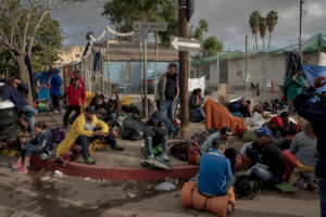
Caravana Migrante, Tijuana
Kitra Cahana
Until it reached the US border in mid-November, the migrant caravan that set out from San Pedro Sula, Honduras, on October 12 had largely been a success. Leaving that crime-benighted…
More
Rêve Géologique
Simona Ghizzoni
Humanity’s impact on the Earth is now so profound that a new geological epoch – the Anthropocene – needs to be declared, according to an official expert group who presented…
More
The Pearl River
Private: Christian Lutz
The Pearl River offers a photographic immersion in Macao, high place of gambling and luxury, a spectacular symbol of a megalomaniac and conquering China. This city with a mythical and…
More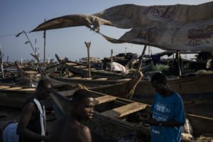
Ghana, Understanding Water
Dominic Nahr
In Ghana, Dominic Nahr has crossed swamps, followed rivers to the beaches and into the Gulf of Guinea. He portrayed the tenuous links between the inhabitants of the Ghanaian coast…
More
H+
Matthieu Gafsou
Transhumanism is an intellectual movement that aims to enhance and augment the human body through the use of sciences and technique. This topic refers to everyday purposes, which are already…
More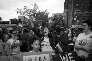
Women march into American politics
John Trotter
After the 2016 election of Donald Trump, a man who campaigned on sexist, racist rhetoric, an unprecedented number of women have decided to run for political office across the United…
More
A Ukraine Runs Through It
Justyna Mielnikiewicz
Project explores modern Ukraine in turmoil with the Dnieper river a metaphor of present split in the country. It documents how the mixed ethnic and historical legacies of Ukraine brought…
More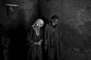
Maqbooza Kashmir
Cédric Gerbehaye
In the last weeks, tensions exploded between India and Pakistan. Warplanes screeched across the sky dropping bombs, and thousands of soldiers mobilized in Kashmir, bringing the two nuclear powers to…
More
"KazaRusy", Russians in Kazakhstan
Justyna Mielnikiewicz
V. Putin his speech in Moscow announcing the annexation of Crimea in March 2014 told the audience «Millions of people went to bed in one country and awoke in different…
More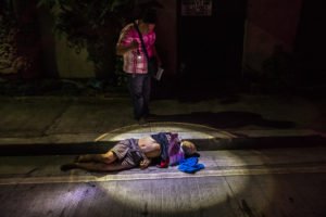
They Are Slaughtering Us Like Animals
Daniel Berehulak
President Rodrigo Duterte of the Philippines, began his anti-drug campaign when he took office on June 30, 2016: since then, according to the Philippine National Police (PNP), 22,983 such deaths…
More
Only God Can Judge Me
Matthieu Gafsou
Matthieu Gafsou was immersed in Lausanne’s drug scene for more than a year. By using various formal approaches, he prosaically and at the same time emphatically documented the life of…
More